TRAX Trip Report – Turon River
Saturday 8th March 2025
Present
Will and Bek – Land Rover Discovery 1
Matt and Alison – Mitsubishi Pajero NX
Eric, Dianne and Laura – Toyota 120 Series Prado
Ralph – Range Rover P38
Phillip and Linda – Nissan GU Patrol
Rob – Nissan GU Patrol
Danny and Janine – Nissan GU Patrol
About the Area
(From NPWS) “Near Lithgow, 185km west of Sydney, Turon Na onal Park is great for remote bushwalking and camping, trout fishing, birdwatching, swimming, mountain biking or canoeing.
If you want to really feel like you’ve gotten away from it all with a remote and rugged bush camping experience, Turon National Park is a fantastic, accessible choice. Just 45km from Lithgow and 185km north of Sydney, here you can explore remote bushwalking and camping in a spectacular se ng that features incredibly diverse vegetation, from wide-open eucalypt forest to silver wattles and river oaks.
The park has a fascinating history, both for its role in the Australian gold mining boom and its early Aboriginal occupation, which is believed to date back thousands of years. History buffs will be intrigued by the evidence of that is s ll highly visible in the park.
You’ll also encounter plenty of interesting birds and animals, such as powerful owls hooting away at night and red wallabies sunning themselves on the sandstone tops during the daytime before descending to the valley at dusk. Be sure to take some me to enjoy a spot of trout fishing, swimming or canoeing on the gorgeously crystal-clear stream that is Turon River”.
Description
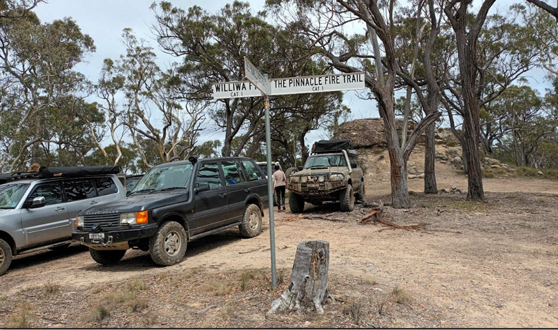
The objective was to reach The Pinnacle for lunch!
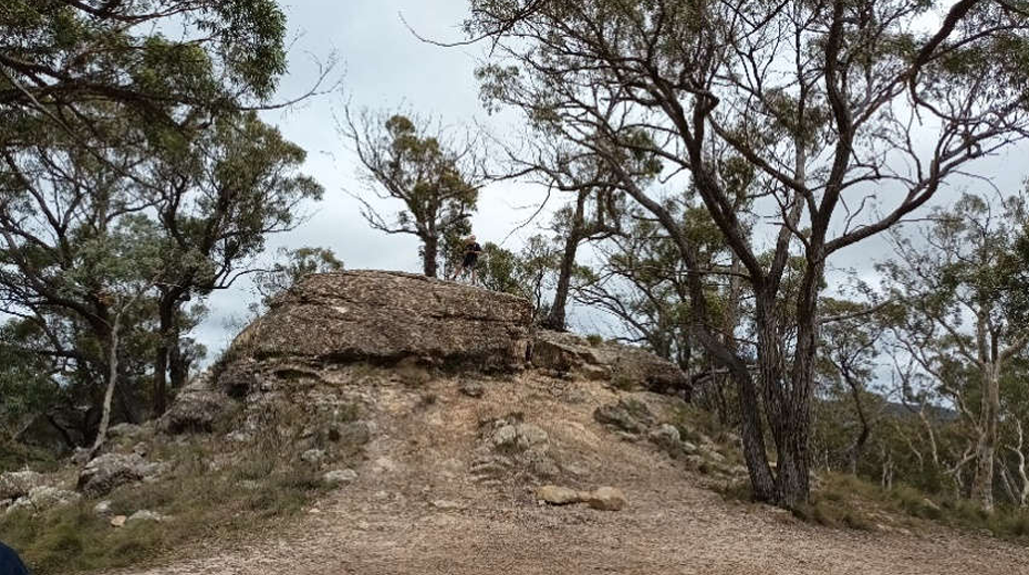
Which we did, but I was not struck so much with the view from the Pinnacle—Laura, Phil, Rob, Bek, Will, Matt, Alison, Eric and Diane—but the fact there was a mix of carvings on the rock.
I jest… the one that really stumped me was the limed imprint of a hand, and the way the lone tree on the rock had set up its root system to collect whatever rainwater landed onto the rock. The rock was also interesting because it was metamorphic conglomerate or river gravel mixed in with sandstone.
After lunch we left the Pinnacle Fire Trail and headed down the Williwa Fire Trail.
But before I talk about the afternoon trip, I thought it’d be worthwhile to explain why I am in fact writing this report. Well, during the week I was pretty busy assisting clients who were facing the real prospect of being flooded by tropical Cyclone Alfred. During the week I received a phone call from Matt just checking that all the paperwork was up-to-date for the trip, to which I replied that I’d sent it out a couple of weeks ago and was pretty sure it’s up-to-date and had included the latest of the latecomers that had signed onto the trip, but that I would check and reissue it the night before the trip.
Some discussion by a couple of attendees evolved in respect of the rain that had possibly been on everybody’s mind because of the cyclone perhaps, and what was the state of the tracks where we were heading and the likely forecast of rain that was expected in Sydney because of the impacts of the cyclone up north. Some discussions and emails per ensued about the fact that generally the week prior to our trip the area had less than 15 mm of rain—considered too likely to be very dry—and in my defence I wanted to go regardless of the weather. I had already booked accommodation for the Saturday night, actually really wanted a break, forget about work, and so a day trip to this area was high on my agenda—go out and enjoy it.
So, I advised that everything is going to proceed after discussions with the trip leader Will and that the start time was to be 9 AM at Petry Park in Capertee as advised by the trip leader. So come Saturday morning I set the alarm nice and early—5 o’clock—thinking if I left at 6 o’clock from Mount Kembla, allowing about three hours with a stop on the way for breakfast, I would easily make Capertee by 9 AM – WRONG!!
So, we left on time—Janine and I all packed in the car and headed down the M7 and M4 and then up the climb of the Blue Mountains, noting that I would stop at McDonald’s at Blaxland for breakfast, and then I knew I needed to stop in Lithgow to try and buy a kettle and some milk/coffee over the trip duration. It was very foggy on our trip up and so we were possibly a bit under speed, and I didn’t want to be pulled over for speeding anyway. So we continued on our way through Blackheath into Lithgow and went shopping for a kettle and milk.
Having lost track of time, it was now 9:10 and I received a phone call—“Where are you?” To which I responded, “In Lithgow buying a kettle.” “What’s wrong?”—Whoops. Then I looked at the time and realised what was wrong—I was still half an hour from Capertee, and I had no kettle. The others said I could use someone else’s kettle, so pull my finger out and get up there—which I did without speeding, arriving at 9:40 AM. I declared a thousand apologies to everybody, to which the reply was that was nowhere near enough—even if I do write the report!!
So, a prayer was said, we aired down, and we commenced on our trip 45 minutes late—thanks to me.
So, as you can see from my summary, there were a number of points about this trip, and the first one was kettles. And of course, I copped kettle jokes all day. For those that know about this and patrols, some of the Patrols were known to be called kettles because they often overheated. As it turned out later today, I also started getting called that because my car was starting to overheat despite all the improvements I’d made to prevent that occurring. After getting home and having a good look at what was going on, I had a radiator full of mud, and it was causing the temperatures to rise in the long climbs out of the valleys we were on today. Even putting lots and lots of water over the radiator to try washing it clean was not working, because the heat had baked the clay into the fins of the radiator. But I was able to get it all out with a gurney once I got home—which was very concerning for me.
So we followed Turon Gates Road for about 1 km, then turned onto Lochaber Link Road and followed it down to the Turon National Park and the Diggings.
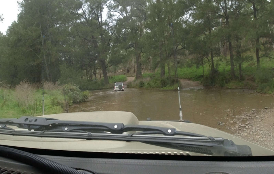
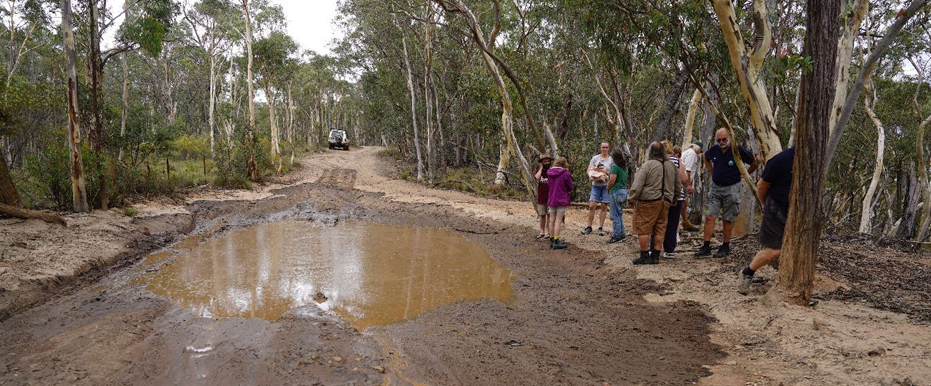
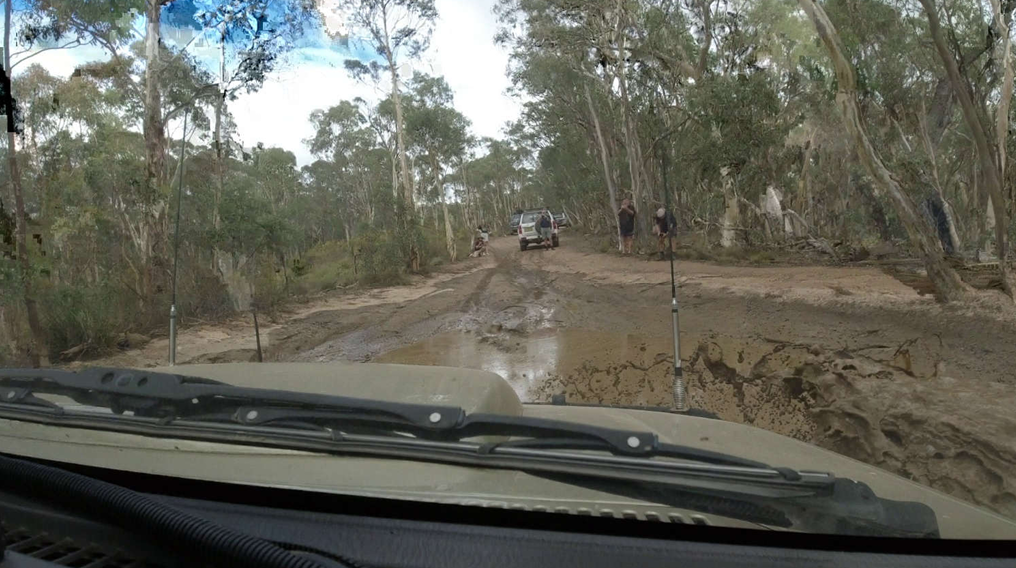
There are a number of creek crossings—water was very clean—but no flow.
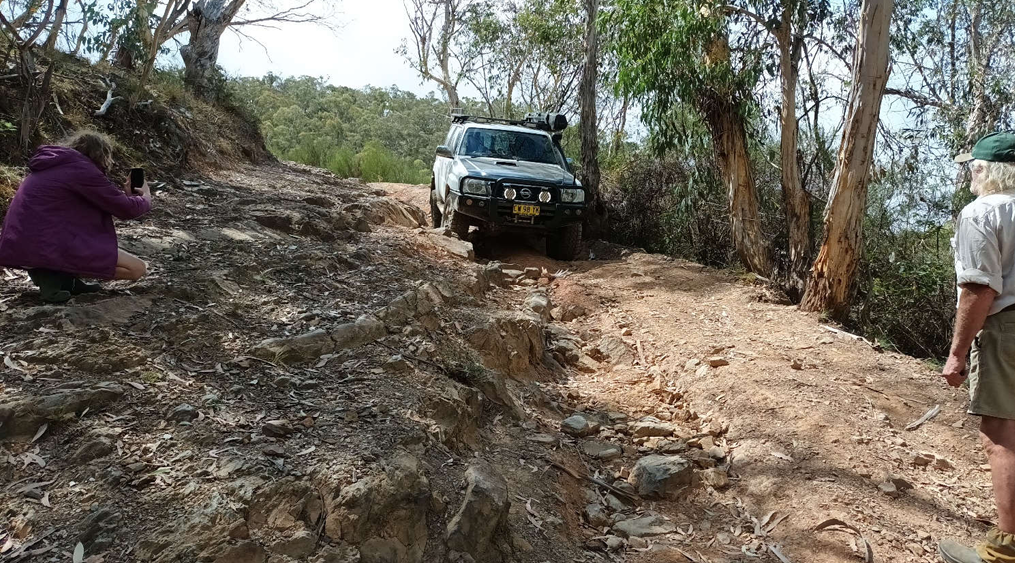
It’s often hard to show how steep a section of track is, or indeed how difficult it may be on film, but as a general rule, look at the number of people taking photos and that will give you a good indication – Ed.
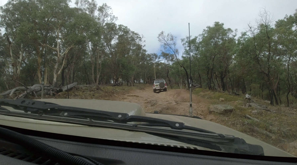
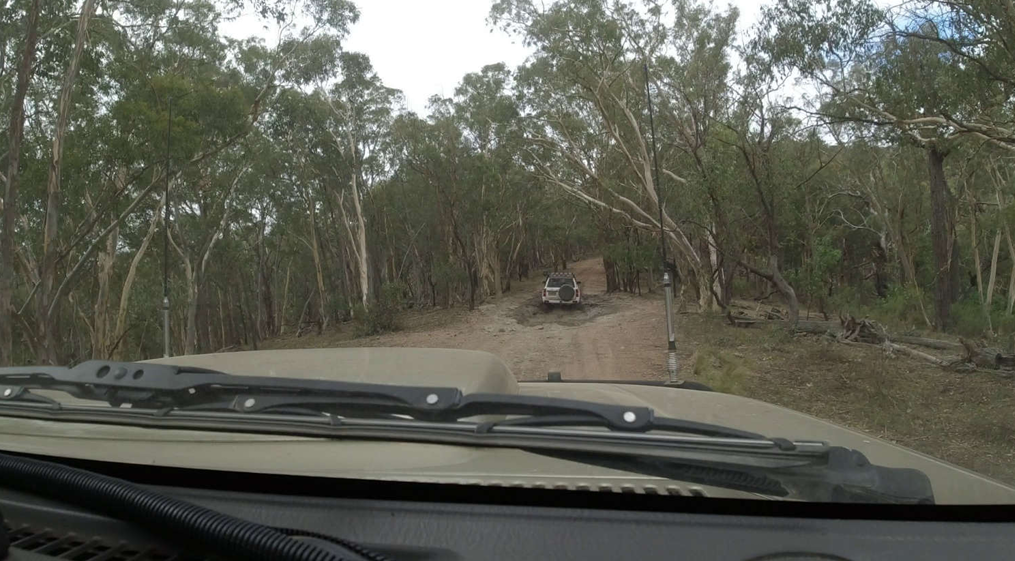
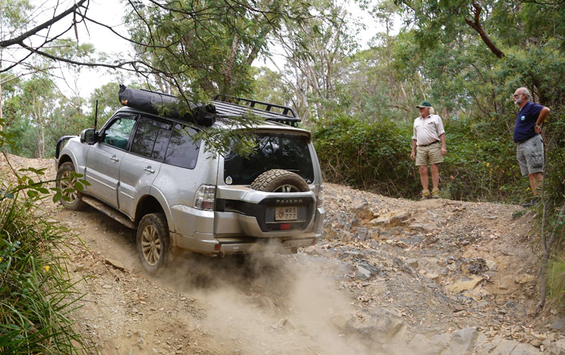
Like all four-wheel-drive trips, the terrain difficulty is often not really appreciated from photographs or videos when you get the opportunity to watch them when you achieve it or some other method. This is not a difficult trip, but there were some sections that involved the requirement of full concentration to avoid panel scratches or damage, because the width of the track was not much wider than the vehicle. Some of the sections were quite technically challenging because of the erosion that occurred in some areas of the tracks, and this caused less articulated vehicles to lose traction relatively easily.
For those that follow us regularly, TRAX is a club that deliberately wants to enjoy God’s creation—not destroy it—so the challenge is for all drivers to be able to explore the terrain with absolutely minimum wheelspin, which reshapes the tracks, loosening up the soil and the gravel and the rocks, and causing erosion every time it rains when the water gets under the rocks and now loosened gravel. I am proud to say that on all the trips I have been on since I’ve been with this club, everybody has medium to high skill levels in driving and as such do take care of the environment to minimise damage.
During the trips, as we travel along the tracks, we’re usually on channel 13 and have various discussions about people who have been on some of these areas before and some of their adventures from those times. And often there is a bit of banter about various things—technically about vehicles or track situations or experiences from other people and third parties—that’s generally shared amongst the group by radio.
I think on this particular trip there were a couple of euphemistic names given to a few items which I thought were funny. First one was a reference to “National Sparks and Wildfires” talking about some of the management options around national parks, obviously. Interestingly, during our trip I made the comment that I was quite surprised that everywhere we went there was very little indication that the park had been through a bushfire at all—let alone in the last 10 or 20 years—because all the trees had no charcoal on them. And that was interesting and from my point of view not explainable given the horrible bushfires that ravaged this general area four or five years ago, particularly around Lithgow where the bush was decimated all the way through the area and around the ZigZag Railway down to parts of the Bells Line of Road, Mount Boyd, etc.
The other one that I thought was funny was that bit of a slur to the “Footpathfinder” whilst talking about the capabilities of different vehicles. We have fun teasing each other and at the same time watching out for each other – mostly….
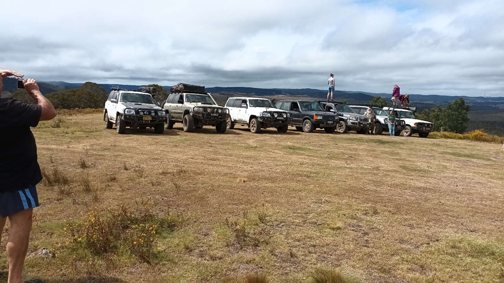
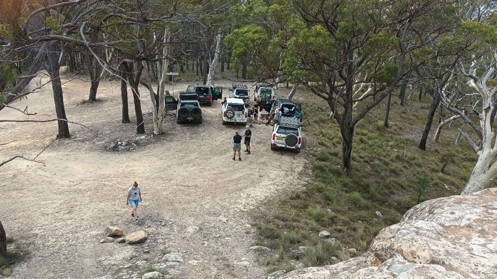
View from the top – well not quite, because we actually started at the lowest point of the trip at Capertee, and whilst we went up and down various hills and parts of the range within the National Park, Sunny Corner was actually the highest part of the whole trip. But in terms of the traverse along the way, this point we are at is the highest vantage point for a 360° view.
It was a great day out. Thank you Will and Bek for planning and navigating the route! I boiled a real kettle and had a cuppa back at my accommodation in Rydal around 6pm!!
Daniel
Trip Convenor
Postscript: Poor Penny Possum
En route we came across a muddy puddle, which had obviously been there for a while. The radio blurted out: “There’s a possum stuck in the mud.” Everyone duly stopped as we investigated this unusual and potentially morbid scene.
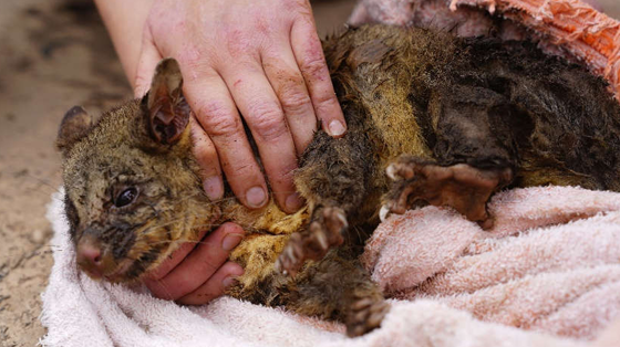
Our own wildlife experts were already on the job when the rest of us came onto the scene, and the possum had been plucked from the mud. It had indeed been caught in the boggier section toward the edge of the bog, but not close enough to free itself. It was quite weak but let us know it didn’t like being handled!
A towel was used for the safety of both the handlers and the possum as it was expertly extracted from the mire. It was carried back to civilisation—Mudgee—in the towel and a box. The next day it was taken to Warrumbungle Wildlife Rescue and Rehabilitation near Mendooran where, after an assessment, it had to be put to sleep.